
Today’s verification session turned into an instance of “forensic meteorology”, as supercell storms occurred yesterday afternoon in two areas that we were not fully aware of.
The first area was Turkey, were the satellite loops indicated several suspicious storms with either strongly left- or right-moving tracks with respect to the Southwesterly upper-level flow. Fig. 1 shows the situation at 1450 UTC. from satellite view.
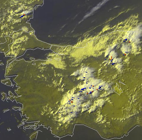
Fig. 1: Nowcast display at 1450 UTC Mon 15 July 2013 (zoom on Turkey): Meteosat E-View satellite image and detected lightning within the last 5 minutes.
Out of the scattered afternoon storms over Turkey, the two Northwesternmost ones in Fig. 1 were most interesting. They were tiny and did not even produce any lightning at that time. However, their V-shaped appearance already marked them as possible supercells. The different orientation of their anvils further indicated their strongly deviant motion, which was confirmed by the satellite loops: the Western supercell moved almost due North, and the Eastern one almost due East.
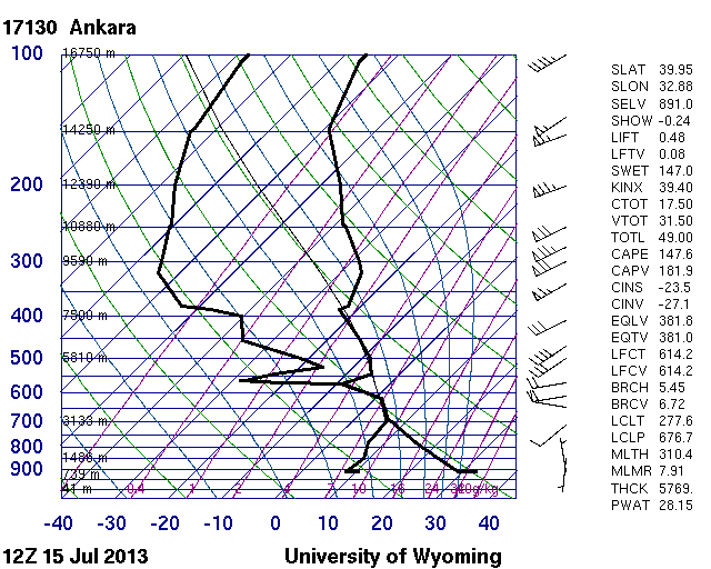
Fig. 2: 12 UTC Mon 15 July 2013 sounding from Ankara (Turkey).
The next step of the “forensic meteorology task force” was to find a proximity sounding. Indeed the 12 UTC Ankara sounding was launched close to the areas of convection (Fig. 2). It showed a typical situation for summertime Turkey with a very deep and dry boundary layer and neutral (i.e., moist-isentropic) lapse rates aloft (disregarding the obviously erroneous measurement at 570 hPa). This is typical for arid regions and strong summertime insolation, when the sensible heat flux is immediately converted into convective mixing. The more eye-catching feature was the rather strong Southwesterly upper-level flow with 20 m/s at 500 hPa. Even though the cloud-bearing layer was remarkably shallow with cloud bases near 3 km and cloud tops near 7 km, the effective vertical wind was indeed considered supportive of “high-based and low-topped supercells” (copyright Pieter).
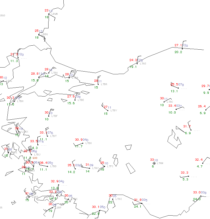
Fig. 3a: 14 UTC Mon 15 July 2013 surface map (zoom onto Turkey).
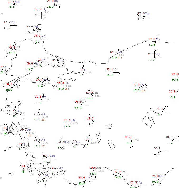
Fig. 3b: 15 UTC Mon 15 July 2013 surface map (zoom onto Turkey).
The 14 and 15 UTC surface maps (Fig. 3a and 3b) also revealed the development of a very strong circulation around the daily thermal low over South-Central Turkey. Eskisehir station (LTBI), situated immediately downstream of the conspicuous left-moving storm in Fig. 1, reported NW wind with 15 m/s at 15 UTC. Further East, Ankara station (LTAC) was not far from the right-moving storm and showed E wind with 5 m/s at 14 UTC. Modifying the sounding in Fig. 2 with these low-level winds would indeed create plenty of negative storm-relative helicity and an enhanced chance for anticyclonic, left-moving supercells around Eskisehir, and vice versa around Ankara, the way it was indeed observed. Ankara also got a direct hit by one of the other storms between 14 and 15 UTC: the temperature dropped from 30 to 18°C, the dew point rose from 10 to 16°C and a maximum gust of 28 m/s was recorded. This confirmed the potential for severe downbursts in such an environment of considerable wind shear and at the same time very dry subcloud layers. [Side note: The allegedly even higher mean wind and wind gusts during fair weather conditions at 15 UTC in Izmir (LTBJ) at the West coast are a coding error – knots were accidentally coded as m/s.]
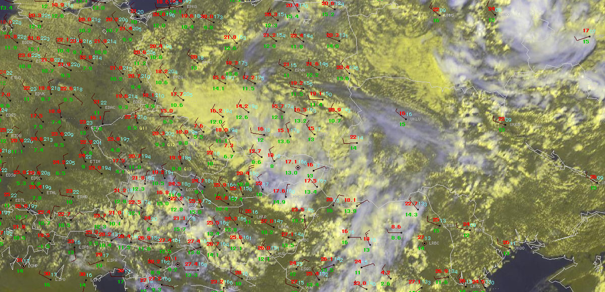
Fig. 4: Nowcast display at 1300 UTC Mon 15 July 2013: Meteosat E-View satellite image, SYNOP observations and lightning detections within the last 5 minutes.
The second area which saw a supercell yesterday (Mon 15 July 2013) was Eastern Hungary, which was crossed by a cold front from the Northwest. A prefrontal environment of a few hundred J/kg of CAPE and deep-layer shear between 10 and 15 m/s in the Northwesterly flow did not look all too conducive for organized storms. However, around noon surface observations indicated that a shallow low formation in the wake of the Slovakian High Tatra mountains made the wind turn back to Southerly directions over a confined region of Eastern Hungary which also still saw enough sunshine. The nowcast display at 1300 UTC (Fig. 4) shows an arc of small cumulus clouds along the cold front from Hungary across Western Slovakia into the Eastern Czech Republic. Ahead of it, the station of Debrecen (LHDC) reported weak Southerly wind. The supercell formed right at that moment in close vicinity and tracked Southeastward. Its long-lived rotation was confirmed by a doppler radar analyses of the Hungarian Meteorological Service (OMSZ) and by pictures taken by spotters. Small hail, strong wind gusts (the highest measurement was 20 m/s) and maybe marginally flooding occurred with this storm.
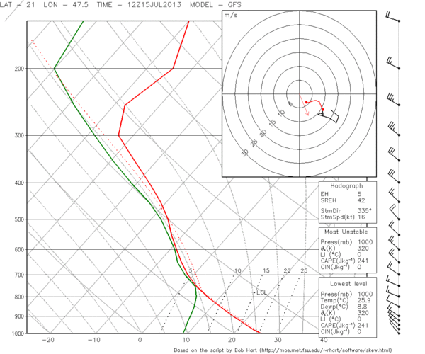
Fig. 4a: GFS forecast sounding for 12 UTC Mon 15 July 2013 for Debrecen (Hungary).
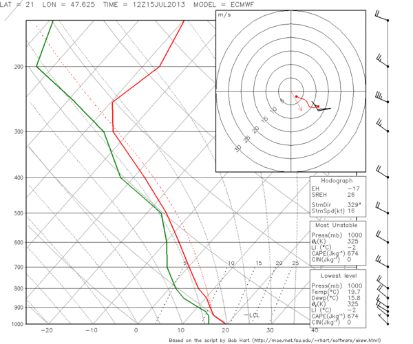
Fig. 4b: As in Fig. 4a, but for ECMWF.
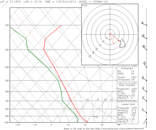
Fig. 4c: As in Fig. 4a, but for COSMO-EU.
It is worth to examine the 12 UTC forecast soundings for Debrecen from GFS, ECMWF and COSMO-EU models (Fig. 5). While the models agreed on a few hundred J/kg of CAPE, the near-surface wind field was forecast in a different way: GFS showed a smooth Northwesterly flow (and consequently a drier boundary layer), ECMWF already weakened the surface winds and COSMO-EU even had signs of a temporary Southerly surface wind, the way it actually occurred. It seems like the finer model resolution helped significantly in capturing this mesoscale low development. Inserting the 13 UTC Debrecen measurements (temperature of 24°C, dew point of 14°C and weak Southerly wind) in the 12 UTC Poprad sounding (Fig. 5), which was already behind the cold front but otherwise in vicinity, indeed yields substantial CAPE and deep layer shear of more than 20 m/s, even more than the most “optimistic” forecast by COSMO-EU had shown.
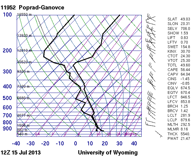
Fig. 5: 12 UTC Mon 15 July 2013 sounding from Poprad (Slovakia).
Both the Turkish and the Hungarian case show situations when mesoscale processes favourably modified the conditions for organized convection despite a rather inconspicuous large-scale setup. Greg mentioned the nice term “mesoscale accidents”, which is colloquially used in the United States for such happenings. The structured land/sea distribution and orography of Europe makes such “mesoscale accidents” in Europe much more common than in the United States.
Today, as many maps as never before were manually drawn at the ESSL testbed: Yesterday’s Hungarian case was so alluring that it was re-analyzed by hand. Further hand analysis were drawn today for the 06 UTC, 07 UTC and 12 UTC maps of the Toulouse domain, which was – despite yesterday’s surprises – again chosen for today’s day 1 forecast. Yesterday a lot of storms occurred there and positively verified our lightning forecast, but severe weather was neither reported from within our level 1 area (see yesterday’s post) nor from anywhere else.
