ICON EPS shows elevated probabilities for excessive rainfall over parts of eastern/northeastern Germany in a 12 hour timeframe from 06 to 18 UTC today (see image). Already yesterday’s ICON EPS highlighted this area for a heavy rain threat. The maximum of the ENS members today even show 12 h accumulations of more than 120 mm in two small areas, which is extreme:
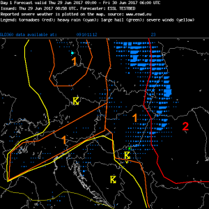
Partly based on this the day 1 forecasting team highlighted the area for a risk of heavy rainfall, while the large level 2 area over eastern Europe is mainly for severe thunderstorms with large to very large hail, severe gusts and maybe a few tornadoes:

