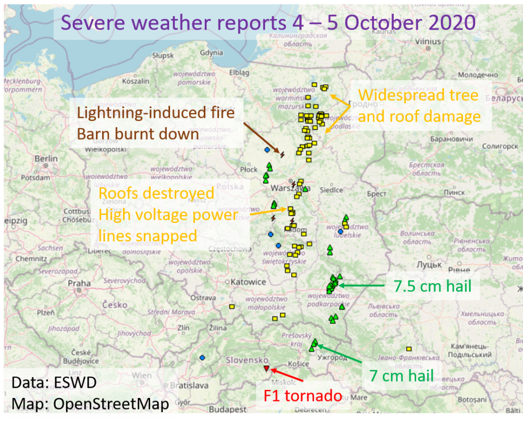
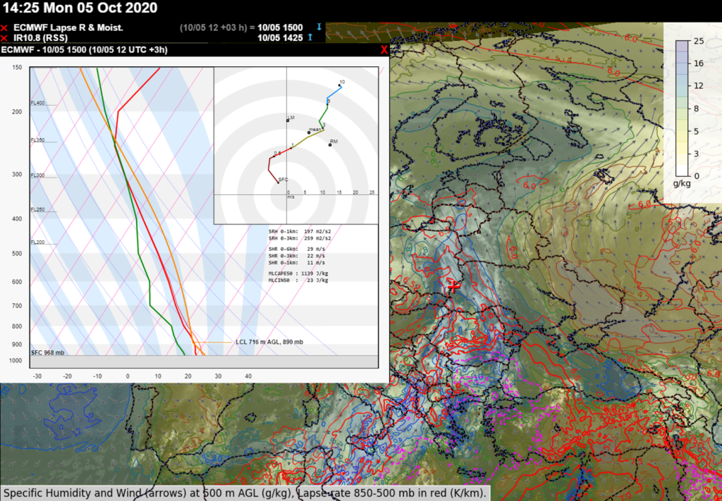
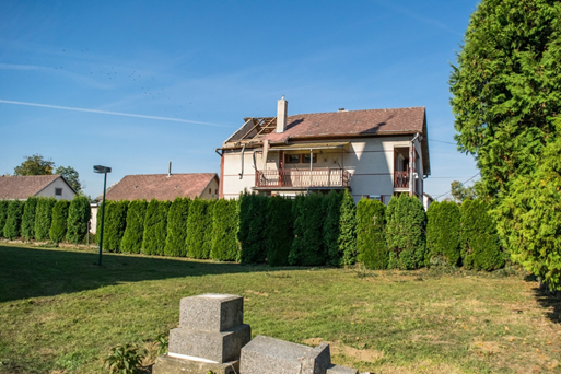
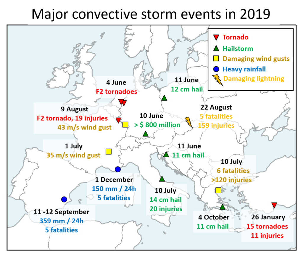
A two-part study on the climatology of severe convective storms over Europe and the U.S. was recently published in the Journal of Climate. The study was led by Dr. Mateusz Taszarek of the National Severe Storms Laboratory (Norman, OK, USA) and Adam Mickiewicz University (Poznán, Poland) with contributions from ESSL among others. The study used lightning detection data, European Severe Weather Database reports, Storm Data reports and the ERA-5 reanalysis to answer the research questions.
The first part, “Severe Convective Storms across Europe and the United States. Part I: Climatology of Lightning, Large Hail, Severe Wind, and Tornadoes“, deals with the climatology of lightning and severe weather reports. In general, there is more lightning over the U.S. and thunderstorms tend to last longer and produce more strikes than over Europe. Over continental Europe, most of the thunderstorms occur during the day, but the opposite is true for the continental U.S., where more than 50% of lightning occurs at night. A higher frequency of thunderstorms at night is observed over the seas, particularly over the southeastern Mediterranean.
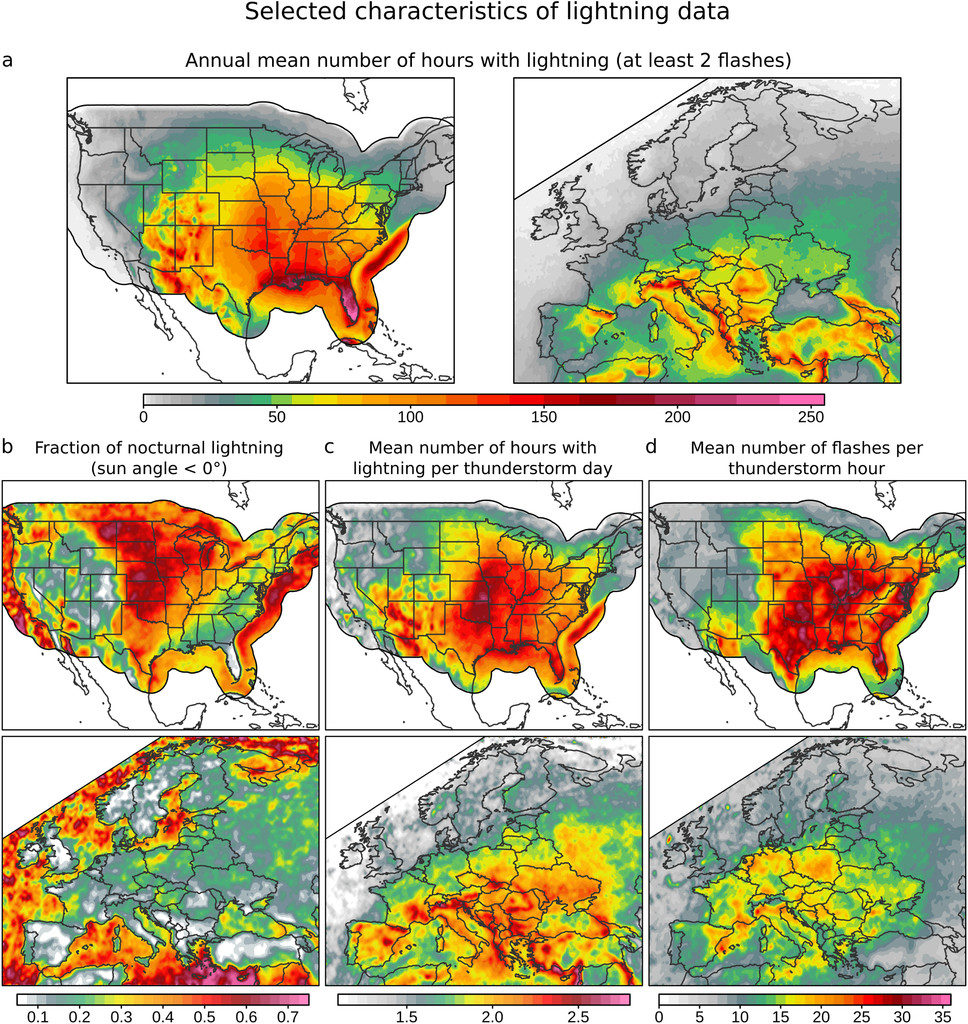
(a) Annual mean number of hours with lightning, (b) fraction of nocturnal lightning, (c) mean number of hours with lightning per thunderstorm day, and (d) mean number of flashes per thunderstorm hour over the United States (1989–2018) and Europe (2006–18). Data are presented in 0.25° boxes with a 0.75° × 0.75° spatial smoother. Nocturnal lightning is defined when a sun angle for a specific grid and date is below 0°.
Copyright of American Meteorological Society, CC-BY License.
Over the U.S., the fraction of lightning hours associated with severe weather reports is higher than over Europe with the exception of winter, when a seasonal maximum is observed over both areas. One can also clearly see stronger reporting inhomogeneity across European countries in contrast to the more homogeneous Storm Data that cover the U.S.. Compared to Europe, extreme events are considerably more frequent over the United States, with a maximum activity over the Great Plains. However, the threat over Europe should not be underestimated, as severe weather outbreaks with damaging winds, very large hail, and significant tornadoes occasionally occur over densely populated areas
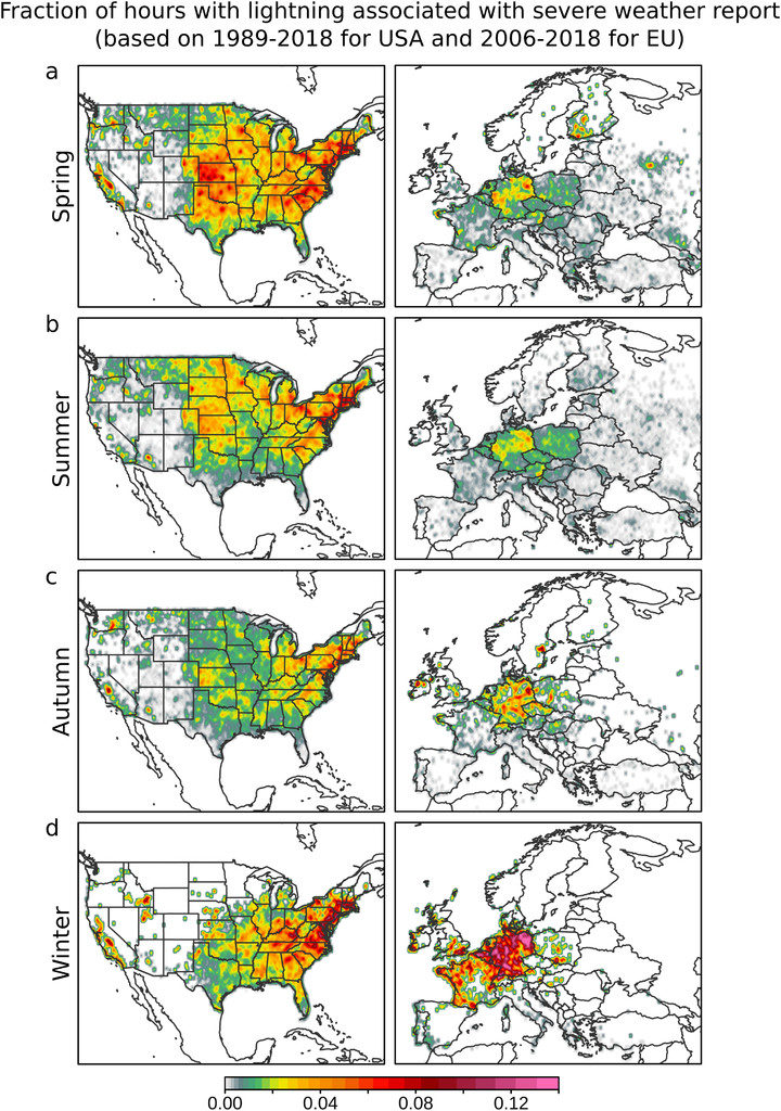
Fraction of hours with lightning associated with tornadoes, large hail, and severe wind over the seasons in the United States (1989–2018) and Europe (2006–18). Data are presented in 0.25° boxes with a 0.75° × 0.75° spatial smoother.
Copyright of American Meteorological Society, CC-BY License.
The second part, “Severe Convective Storms across Europe and the United States. Part II: ERA5 Environments Associated with Lightning, Large Hail, Severe Wind, and Tornadoes“, deals with the environments of severe convective storms and their hazards derived from the ERA-5 reanalysis. The U.S. experiences more extreme severe convective storm environments than Europe when considering how often high CAPE, strong vertical wind shear and high Storm Relative Helicity (SRH) occur. This explains why tornadoes are rarer over Europe than over the U.S. On the other hand, 0-3km CAPE is higher and low-level lapse rates are steeper over Europe.
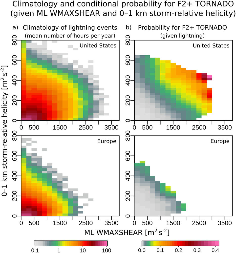
(a) Scaled mean number of hours per year with lightning and (b) conditional probability as for significant tornados (F2+) given specific ML WMAXSHEAR (product of square root of 2* MLCAPE and 0-6 km bulk shear) and 0–1-km storm-relative helicity parameter space.
Copyright of American Meteorological Society, CC-BY License.
While environments conducive to severe convection (characterized by the simultaneous occurrence of CAPE and shear) occur more frequently over the U.S., European severe storm environments more frequently result in storms. 30 – 40% of the thunderstorms over the midwest of the U.S. form in conditions conducive to severe weather, in contrast to 10 – 25% of thunderstorms over central and western Europe. Over Europe, the highest fraction of thunderstorms forming in severe environments is found over the Balearic Sea and the northern Adriatic Sea.
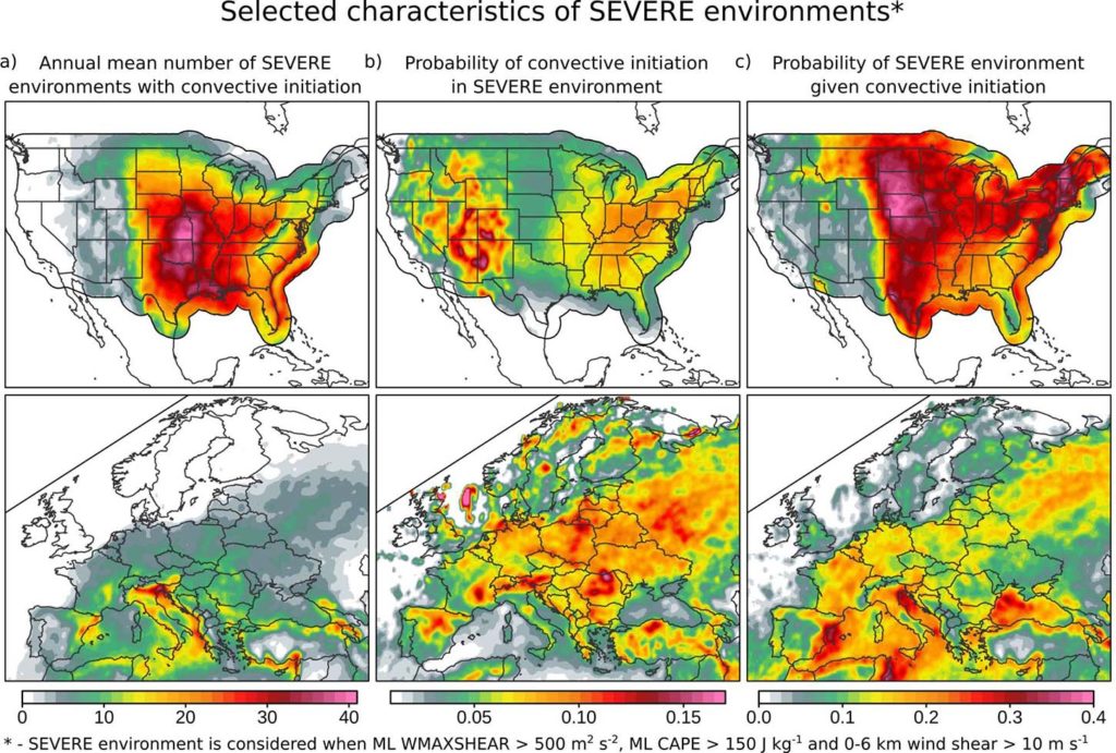
(a) Annual mean number of situations (hours) with severe environments and lightning detection (at least 2 flashes), (b) probability of convective initiation in severe environment (fraction of severe environments associated with lightning), and (c) probability that a developing thunderstorm will be be associated with severe environment (fraction of lightning events associated with severe environments).
Copyright of American Meteorological Society, CC-BY License.
Additionally, an animation of the annual cycle of lightning activity, MLCAPE and 0-6 km vertical wind shear over both areas can be seen below. Over Europe, one can see a shift of thunderstorm activity from land to sea as the year progresses from spring and summer to autumn. In both areas, the seasonal increase in CAPE is accompanied by a decrease in shear and vice versa. The U.S. Midwest sees a pronounced combined occurrence of high CAPE and strong shear in the spring, while it occurs across western Mediterranean in autumn.
Taszarek, M., Allen, J. T., Groenemeijer, P., Edwards, R., Brooks, H. E., Chmielewski, V., & Enno, S. (2020). Severe Convective Storms across Europe and the United States. Part I: Climatology of Lightning, Large Hail, Severe Wind, and Tornadoes, Journal of Climate, 33(23), 10239-10261. Retrieved Dec 9, 2020, from https://journals.ametsoc.org/view/journals/clim/33/23/jcliD200345.xml
Taszarek, M., Allen, J. T., Púčik, T., Hoogewind, K. A., & Brooks, H. E. (2020). Severe Convective Storms across Europe and the United States. Part II: ERA5 Environments Associated with Lightning, Large Hail, Severe Wind, and Tornadoes, Journal of Climate, 33(23), 10263-10286. Retrieved Dec 9, 2020, from https://journals.ametsoc.org/view/journals/clim/33/23/jcliD200346.xml