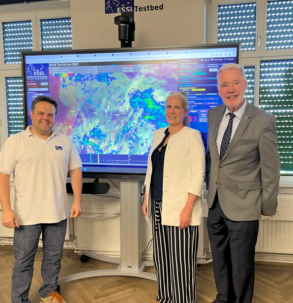
On the occasion of the first EUMETSAT-ESSL Testbed in 2023, the mayor of the city of Wiener Neustadt, Klaus Schneeberger, and the head of the governmental science department of the Federal State of Lower Austria, Martina Höllbacher, paid a visit to ESSL this week.
From left to right: Alois M. Holzer (Director of Operations, ESSL); Martina Höllbacher (Head of Science, Federal State of Lower Austria); Klaus Schneeberger (Mayor, City of Wiener Neustadt)
ESSL staff informed the officials on the anticipated advances in connection with the new satellite generation (EUMETSAT MTG). Our guests have been impressed by the variety of impactful activities the small ESSL team has undertaken over the past years, as documented by scientific posters and by the growing list of events, ranging from testbeds and seminars to expert workshops.
The official visit took place on 8 June 2023. The next day, a science journalist from the Austrian Broadcasting Corporation (ORF) visited our ESSL Research and Training Centre to interview participants and prepare a report on the EUMETSAT-ESSL Testbed and its importance for operational meteorologists in Europe. This week, participants from 15 different countries are taking part, from Ireland to Turkey, and from Portugal to Finland.
ESSL and collaborators drafted a document on the “International Fujita Scale” (IF-Scale). It defines a new method to rate tornado and wind damage and was presented at the European Conference on Severe Storms in Bucharest, Romania, earlier this month.
The document is open for commenting until 31 May 2023. ESSL plans to implement the new scale in the European Severe Weather Database by 1 July 2023.
More information on the IF-Scale draft you can find here.
The workshop is scheduled for autumn, from 16 to 18 October 2023, and takes the very broad view. Target audience are forecasters (“warners”) and heads of forecasters, researchers and practicioners related to warnings, civil protection authorities, and end users of warnings (especially from critical infrastructure).
The following topics will be covered:
The broad
multidisciplinary view: risk ethics (philosophy, moral reasoning), human
behaviour (psychology) and legal frameworks (just) in the context of the
warning process
Limitations
and new prospects for ingredients-based warning approaches: How should the risk
matrix be defined? Can more life be brought to forecasting impacts beyond the
marketing term?
Communication
– dealing with uncertainty: Why is there so little progress in communicating
the warning uncertainty, and how can this be improved?
Action
advice and public education: from understanding to response and action. We are
seeking for good practice examples.
General
and tailored warnings: What are the necessary differences? And how can the gaps
between warners, emergency managements and end users be best bridged?
From
physical ingredients to impact warnings: Are impacts in high-end meteorological
events easier to predict and stronger tied to the physical magnitude than in
more frequent and modest events?
A critical
moment in the meteorological sphere: transition from forecasting to nowcasting
and the resulting potential sudden jump in probability of extremely rare
events. Should there be a stronger focus on the warning means in the “last
hour”? When in time and at which probability and intensity threshold should
sirens and other “strongly interrupting and potentially also frightening” means
of warning be used?
Cross-institutional
and cross-border communication: What is needed to ensure the flow of relevant
information in extremely time-critical and high workload situations?
Warners at work at the EUMETSAT-ESSL Testbed 2022
A detailled invitation can be downloaded here (PDF).
The registration for the 11th European Conference on Severe Storms is open and normal registration fees apply until 7 April. Starting 8 April, late registration fees do apply.
Please register here for on-site participation or online streaming (remote presentations are not foreseen).
General information on the ECSS including the scientific and social programme can be found here.
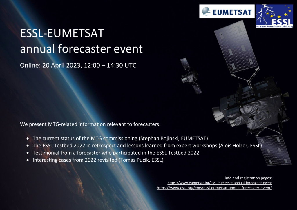
This webinar features key 2022 results from the joint
ESSL-EUMETSAT activity introducing MTG data to operational weather forecasters
in Europe. ESSL trainers describe highlights of severe convective weather cases
that were analysed by forecasters during the testbeds in Wiener Neutstadt.
Forecasters provide testimonials on their testbed experience and the importance
of satellite products in the forecasting process. In addition, the ESSL expert
workshops put the spotlight on novel MTG products such as the 0.9um FCI channel
to detect low-level moisture, or the Lightning imager. The audience will learn
about key take-aways from these workshops, for later use in training on MTG for
all users.
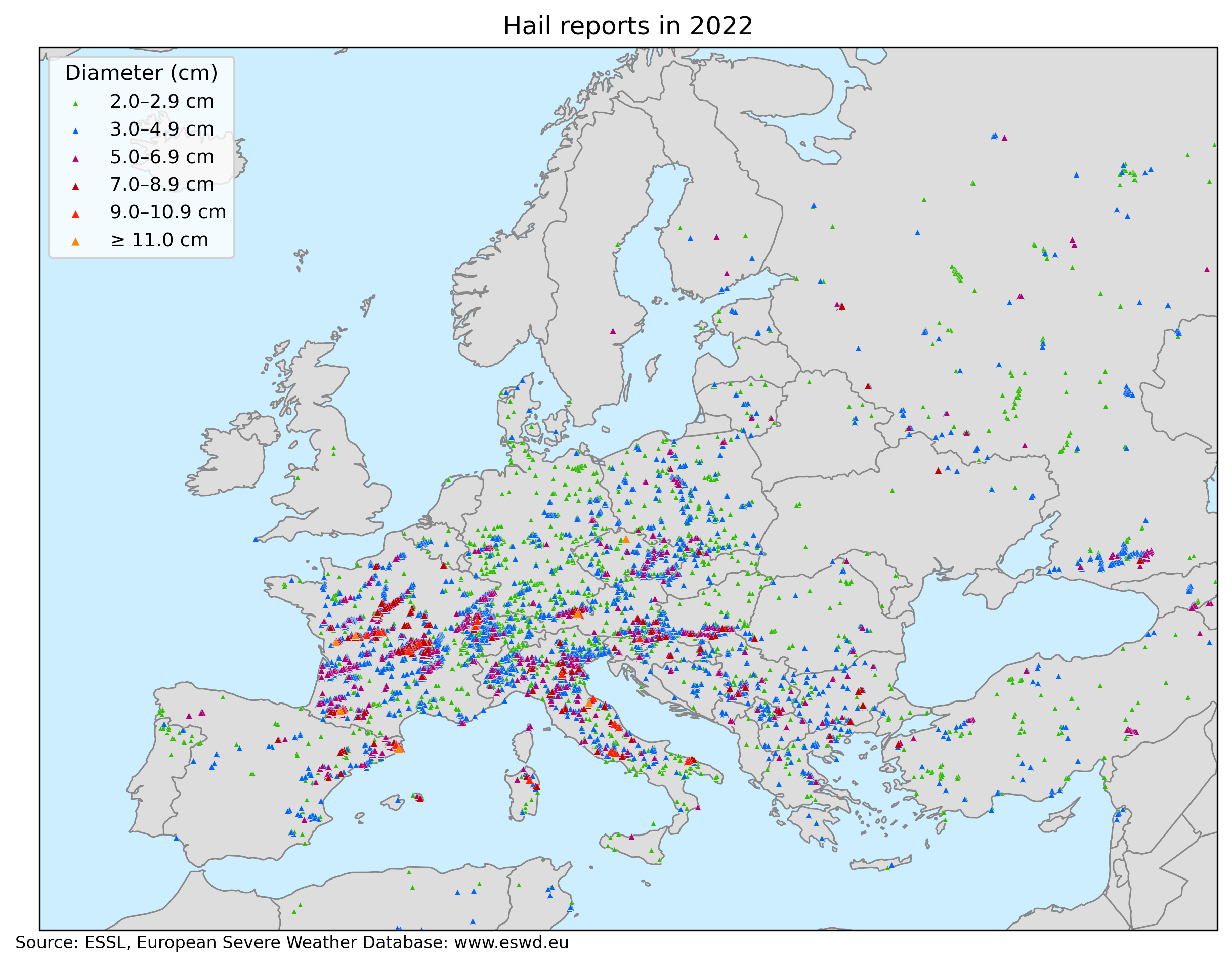
The year 2022 was another record-breaking year for hailstorms in Europe. In total, 8224 large hail reports (≥ 2 cm in diameter) were submitted to ESWD. That is 2791 more than in 2021, which was already a record-breaking year. Very large hail (diameter ≥ 5 cm) was reported 1334 times and 18 reports involved giant hail with a diameter ≥ 10 cm. There were 213 days with at least one large hail and 94 days with at least one very large hail report. The period of 20 May to 10 July was particularly active concerning very large hail. Out of 52 days, very large hail was observed on 42 of them.
Large hail reports in Europe in 2022 based on the European Severe Weather Database.
By far the largest number of reports was submitted for France (2461), followed by Italy (993) and Germany (583). The three days with the most hail reports were 4 June (411 reports), 20 June (385 reports), and 25 May (334 reports). Hail injured 215 people and killed 1. The two most societally impactful events were the Casamassima (Italy) hailstorm on 19 August with 100 injuries and the La Bisbal d’Empordà (Catalonia) hailstorm on 30 August with 67 injuries and one fatality. Hailstorms had a very large economic impact, especially in France, where the insured losses reached 4.8 billion € according to Swiss-Re. While some of the hailstorms produced large hail only for 15 minutes, some lasted for more than 3 hours. The longest-lasting hailstorm occurred on 22 May in France, producing large hail for 5 hours in a hail swath over 300 km long.
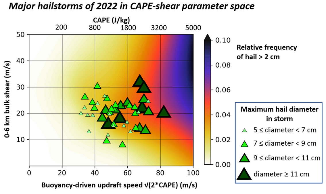
Major hail events of 2022 formed in a large range of CAPE and shear values. That said, the majority of the events occurred with CAPE exceeding 1000 J/kg and 0-6 km bulk shear exceeding 15 m/s, which is a parameter space where the large hail typically occurs. Some of the giant hail-producing events had a rather unremarkable environment. A good example of such a case is the hailstorm of 1 July over Czechia, which produced hail up to 11 cm in diameter with CAPE around 1000 J/kg and 0-6 km bulk shear well below 20 m/s. Giant hail was produced briefly following the merger of two storms. Hail around 3 cm in diameter was observed pre-merger and no large hail followed the brief period of giant hail production. This shows the importance of storm-scale processes, which can’t be captured by looking at the large-scale environment.
Major hailstorms of 2022 in CAPE and 0-6 km bulk shear parameter space based on the ECMWF data. Background colors represent the relative frequency of hail > 2 cm acquired from the additive logistic regression model ARCHaMo for large hail (Battaglioli et al. 2023, submitted).
The biggest hailstorm cases of 2022:
20 May: Several hailstorms impacted northern France and western Germany. The largest hail, 8 cm across, fell in Sedan, France. Most hail damage was produced by a hailstorm that passed the northern suburbs of Koblenz, Germany, damaging roofs, windows, and cars. The largest hail reached 6 cm there.
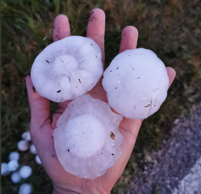
22 May: A supercell tracked for more than 300 km across west-central France, impacting the towns of Niort, Poitiers, Chauvigny, and Chateauroux. Supercell produced hail for 5 hours with several peaks of activity, when the hail diameter exceeded 8 cm in diameter. The largest measured hail was 12 cm in diameter, but even larger may have fallen with reports of weight up to 780 g. Chateauroux was hard hit with hailstones up to 9 cm in diameter. 4 people were injured and the hail badly damaged 250 houses and 1000 cars.
One of the giant hailstones that fell on 22 May in France. Source: https://www.francebleu.fr/infos/faits-divers-justice/en-images-a-frontenay-rohan-rohan-des-grelons-comme-des-oranges-1653307396
25 May: Several supercells produced long hail swaths over southeastern Austria, Slovenia, northeastern Croatia, and Hungary. The largest hail measured 8 cm in diameter. Severe damage to buildings was reported in Kapela Podravska, Croatia, and Kiskorpád, Hungary.
28 May: South-moving hailstorm produced damage east of Milan. The largest hail reached 7 cm in diameter. A hail up to 8.5 cm in diameter was reported in the Smolan region, Bulgaria, damaging cars, roofs, and agriculture.
29 May: A woman was injured by very large hail in Italy. Hail up to 7.5 cm in diameter caused significant damage to roofs, cars, and greenhouses in Orizari, Bulgaria.
2 June: Severe hailstorms impacted southeastern Austria, Slovenia, and northern Croatia. Damage to crops, houses, and cars was reported. The maximum hail size reached “only” 5 cm, but hail fell in large quantities and was accompanied by severe winds in many locations with drifts up to 20 cm deep.
3 June: Hailstorms affected southern France. The largest hail measured 7.5 cm in diameter and the longest hailstreak was 150 km long.
4 June: Widespread hail damage was reported in central France, particularly in Vichy and surrounding areas. Hail reached up to 10 cm in diameter, severely damaging cars, roofs, and agriculture. 1 person was injured by hail in Vichy.
5 June: Hailstorms impacted eastern France, Switzerland, northwestern Italy, Slovenia, Austria, and Serbia. Hail up to 9.5 cm was reported in Frankolov, Slovenia, and an 11 cm hailstone fell in Kufstein, Austria.
19 June: A long-lived, right-moving supercell produced an almost 350 km long hail swath across France, affecting the outskirts of Orléans. The supercell produced hail for 4 hours. Roofs and cars were damaged along the path of the storm and the largest hail, measuring 8.5 cm, fell in Chambord and Saint Cyr en Val.
20 June: A long-tracked supercell crossed northern Bordeaux and destroyed more than 5000 hectares of agriculture with wind-driven hail in Dordogne. The largest hail diameter reached 7 cm. Serious damage to roofs and cars was reported in some parts of the hail swath. North of Pyrennees, a hailstorm produced giant hail with a maximum estimated hail size of 13 cm in Vic en Bigorre with widespread damage to roofs and cars. Long-lived supercells with hail also affected southern Germany and southeastern Czechia, but hail did not reach 5 cm.
21 June: Third day of severe hailstorms in France in a row. Wind-driven hail up to 9 cm in diameter impacts regions of Auvergne and Bourgogne, destroying agriculture, roofs, windows, and cars. House facades and sides of cars suffered extensive damage as the hail was blown horizontally in the strong wind. A video showing the combination of severe winds and very large hail can be found here. Another long-lived supercell produced hail up to 8 cm, severely damaging roofs and cars in the region of Morvan. Very large hail also fell in Italy, Slovenia and Serbia. In Serbia, hail up to 7 cm in diameter caused severe damage to agriculture and roofs in the Moravički region.
Damage to the vehicles by the wind-driven hail in Digoin, France. Photo taken by Christophe Asselin (Chroniques Chaotiques).Damage to the vehicles by the wind-driven hail in Digoin, France. Photo taken by Christophe Asselin (Chroniques Chaotiques).
23 June: Hail and windstorm impacted Podgorica, Montenegro with damage to agriculture and cars. Largest hailstones reached 5.5 cm. Hail up to 8 cm in diameter was observed in Sfélinos, northern Greece.
26 June: Severe hailstorms affected eastern France with hail up to 7 cm in diameter. One of the storms also impacted Strassbourg and its outskirts and many cars were damaged.
27 June: Very large hail up to 8 cm in diameter was reported from southern Germany as two supercells tracked along the northern edge of the Alps. 7 cm hail was reported in western Czechia.
28 June: 1 person was injured by very large hail in Kastoriá, Greece.
29 June: Widespread large to very large hail was reported in eastern Czechia and southern Poland.
30 June: Very large hail fell in France, Italy, northern Czechia, Poland, and Bosnia-Herzegovina. The largest hail, 8.5 cm across, was reported in Blamont, France.
1 July: Giant hail up to 11 cm in diameter fell in Rovensko pod Troskami, Czechia. Very large hail also fell in eastern Czechia and western Slovakia from two long-lived supercells. Splitting supercells produced hail up to 6 cm in diameter in the Veneto region, Italy.
5 July: Severe hailstorm impacted southwestern Serbia. Hail up to 7 cm in diameter damaged crops, roofs and cars.
4 July: Very large hail up to 6 cm in diameter injured 2 in Castel Maggiore.
7 July: Several supercells formed in Veneto, Lombardia, and Emilia-Romagna regions in Italy, each producing very large hail. Widespread damage to cars, windows, and roofs was reported. The largest hail fell in Ostiglia and was estimated to be 9 cm in diameter.
Very large hail that fell in Revere-Ostiglia area on 7 July. Photo taken by Luca Vezzosi.
20 July: Severe hailstorms occurred in Switzerland and eastern France. The most severe storm affected the region of Franche-Comté and the commune of Doubs, where hundreds of roofs, windows, and vehicles were badly damaged. The largest hailstone fell in Le Russey, estimated at 9 cm across.
27 July: Very large hail was reported from the Abruzzo province in Italy. The largest hail, 9 cm in diameter, fell in Teramo and Ascoli Piceno. Damage to cars, roofs, and windows occurred.
28 July: Left-moving supercell produced very large hail up to 8 cm in diameter near Lleida, Spain, damaging roofs, cars, windows, and greenhouses.
13 August: Southward moving supercell produced a long hail swath across Sardegna, a rather rare occurrence on the island. The largest hail was estimated to be 9 cm in diameter and fell in Alà dei Sardi.
17 August: Widespread large to very large hail was reported from southern France. The largest hail fell in Bonnétage, estimated at 8 cm across. In Catalonia, a woman was slightly injured by a 5 cm hailstone.
18 August: The event known especially for the powerful derecho producing wind gusts exceeding 60 m/s over Corsica also featured a number of damaging hailstorms. In the early morning hours, wind-driven hail injured 22 people in Sestri Levante and Lavagna in Liguria, Italy. Hail damaged cars, windows, and facades of houses. Around noon, a hailstorm struck Menorca with hail up to 7 cm in diameter. In the evening hours, another series of hailstorms impacted Italy, especially the regions of Marche and Tuscany. The largest hail, 11 cm in diameter, fell in Macerata Feltria damaging cars, and roofs and injuring 1 person.
19 August: Giant hail, reaching 10 cm in diameter, was reported from Casamassima, damaging cars, and windows. At least 100 people were lightly injured by hail. Most of the injuries were inflicted by broken glass. The number of injuries ranks as the third highest recorded in the ESWD for large hail events.
Very large hail that fell on 19 August in Italy. Photo taken by Michele Connena.
30 August: In the late afternoon, a supercell storm formed over the eastern Pyrenees. The storm moved southeastward and entered the district of Girona in Catalonia, producing a swath of very large hail (≥ 5 cm) between Esponnellá and Tamariu. Multiple reports of hailstones larger than 10 cm in diameter were collected with the largest stones estimated to be 12 cm. Impressive videos of the hailfall can be found here or here. Besides serious damage to roofs and cars, 67 injuries and even one fatality (a 2-month-old baby) resulted in the town of La Bisbal d’Empordà. 28 people had to be taken to the hospital, including one serious head injury. This was the first direct hail fatality in Europe since 1997. Furthermore, the number of injuries ranks as the fourth highest recorded in the ESWD for large hail events.
Giant hailstone that fell in Catalonia on 30 August 2022. Source: https://mobile.twitter.com/Supercelulas
8 September: Southeastward moving supercell over Lazio, Italy produced a swath of very large hail. The largest hail, 9 cm across, fell in Boville Ernica.
27 September: Serious hail damage to roofs, cars, windows, and greenhouses was reported from Serbia, especially in Pomoravski okrug region. Hail reached up to 6 cm in diameter.
23 October: Intense storm that resulted in a long-tracked tornado in Haute-Normandie, northwestern France also produced very large hail up to 7.5 cm in diameter.
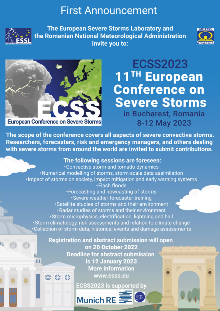
We cordially invite you to submit a contribution to the 11th European Conference on Severe Storms to be held from May 8th to 12th in Bucharest, Romania.
20 January 2023 will be the final deadline for abstract submission.
The new EUMETSAT MTG-I (Meteosat Third Generation – Imaging) satellite, launched on 13 December, will bring more frequent data with higher spatial resolution and more channels than ever before. With the lightning imager, it will also bring a completely new capability to monitor storms from space.
ESSL collaborates with EUMETSAT as part of its User Preparation programme for the new MTG satellites with its testbeds and ESSL training activities.
MTG low level moisture proxy data (from MODIS) visualized in the EUMETSAT-ESSL Testbed Displayer for 21 June 2022: dark blue areas are very moist, green areas show moderate and yellow areas low moisture content of the lower troposphere. High quantities of moisture are crucial for severe storms to form.
Operational data from the new MTG-I1 satellite will become available in the second half of 2023 if everything goes well. The current cooperation between EUMETSAT and ESSL involves training on how to use the new data. At the EUMETSAT-ESSL Testbeds weather forecasters are being prepared so that they are able to quickly make use of the new capabilities of MTG. Besides providing training, ESSL experiments with new products, such as a visualization of atmospheric moisture very close to the ground – an important physical ingredient for convective storms.
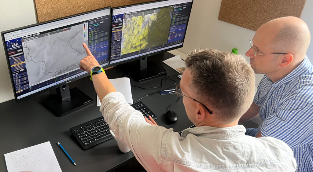
Participant of the recent EUMETSAT-ESSL Testbed analyzing satellite data at the ESSL Research and Training Centre in Wiener Neustadt, Austria, including the newest version of NWC SAF products (CI product in this case). MTG will offer much improved temporal and spatial resolution for such products.
Another focus of the multi-year cooperation between EUMETSAT and ESSL is the preparing for the new lightning imager (LI) data aboard MTG.
Testbed participants providing feedback to the developers of novel satellite products at the EUMETSAT-ESSL Testbed.
The “Second Announcement and Call for Papers” has been published for the 11th European Conference on Severe Storms. The ECSS2023 will take place from 8 to 12 May 2023 in Bucharest, Romania.
The scope of the conference covers all aspects of severe convective storms. Researchers, forecasters, risk and emergency managers, and others dealing with severe storms from around the world are invited to submit contributions.
Abstract submission and registration for the conference are now possible here. The deadline for abstract submission is 12 January 2023.
In addition you might also be interested in other topics from our latest ESSL Newsletter:
The official first announcement for the 11th European Conference on Severe Storms, to be held in Bucharest from 8 to 12 May 2023, was published by ESSL today.