Early season tornado outbreak over Turkey

While much of Europe remains under stable conditions, severe weather outbreak occurred over Antalya province, southern Turkey, between 24th and 26th January 2019. Outbreak included numerous instances of heavy rainfall resulting in flash floods, tornadoes, severe wind gusts and large hail (Fig. 1).

Fig. 1 Reports of severe weather between 24th and 26th January over Turkey based on ESWD.

On 24th January, three tornadoes affected the province, one of them rated F2, killing 1 and injuring 6 people. 2 F1 tornadoes occurred as well, injuring 1 person. Tornadoes inflicted considerable damage to homes, roofs and greenhouses.

On 25th January, flash flooding has killed 2 people in the same area.

On 26th January, a strong tornado, rated F2, struck Antalya airport, injuring 11 persons at the site. 8 passengers were injured on a transfer bus that was overturned and dragged by severe winds. 3 airport employees were injured in another shuttle. The event has gained significant attention on the social media as many videos and photographs were taken of the tornado. Tornadic storm would later produce additional F1 tornado and also instances of very large hail, damaging greenhouses.

This tornado outbreak is interesting from two aspects. The first is its occurrence in the middle of winter and out of the convective season throughout much of Europe. However, recent research on tornado climatology (Groenemeijer and Kuhne, 2014; Kahraman and Markowski, 2014) shows that January is actually the month with peak tornado activity over this part of Turkey (Fig. 2). A relatively warm sea with strong flow aloft combined to create marginal CAPE, low cloud bases and pronounced vertical wind shear in the lower troposphere (Fig. 3)

Fig. 2 Month with peak tornado activity over Europe from Groenemeijer and Kuhne (2014).

The second interesting aspect is that it shows the potentially high societal impact that tornadoes may inflict when striking vulnerable infrastructure, in this case an airport. Had the tornado been stronger and/or larger, the impact could have been much worse, with hundreds to thousands of people in danger. While tornadoes are considered rare in Europe, this is actually the second time in less than two years that a tornado got in close proximity of an airport, after the Vienna Schwechat airport incident on 10th July 2017. Tornadoes are in general an underestimated threat in Europe (Antonescu et al, 2017) and this recent case demonstrates a strong need to include tornadoes in national weather warning systems.

Fig. 3 Forecast of CAPE and bulk 0-3 km vertical wind shear for 26th January 2019, 06 UTC, based on 00 UTC run of ICON.


Deadly flash floods in 2018

In our recent blog post about very large hail events of 2018, we mentioned that hail produces large damage. However, it is rarely deadly, in contrast to flash floods. Based on the data from  the European Severe Weather Database, by 12 December, flash floods have killed 152 people across Europe, parts of northern Africa and the Middle-East.

While most of the heavy rainfall events were reported in central Europe, the most deadly flash floods occurred in the Mediterranean area, including the 5 events with the highest number of fatalities, ranging from 12 to 21.

Heavy rain and deadly flash flood reports across Europe in 2018. 5 events with the highest number of fatalities are indicated.

Who was at most risk during the flash floods? Out of 35 events with more than 1 fatality we identified 16 that involved vehicles being swept away by the floods. Because not all reports include detailed description of the fatality circumstances, the ratio of events including fatalities in cars is likely even higher. The deadliest flash flood also involved a vehicle. In a tragic event on 25 October, a flash flood swept away a bus in Jordan, killing 21 persons onboard.

Besides vehicles, several events involved a group of hikers being swept away by flash floods in the narrow canyons. The first such event occurred in Israel, on 5 May and resulted in 10 fatalities. On  1 August, 5 hikers were killed on Corsica and 10 hikers drowned in the Pollino national park in Italy on 20 August.

This shows that data from the ESWD can be used not only to identify the areas with the highest severe weather incidence, but also to compare the impacts of severe weather phenomena or to find out which groups of people are at most risk in a given severe weather type.

Upgrade of severe weather database ESWD

Based on feedback from ESWD users collected at meetings in November 2017 and the ESWD User Forum in March 2018, the European Severe Weather Database has been updated to Version 4.4.

A number of changes have been made, particularly to the submission form. The most important changes are:

1. Kyrgyzstan, TajikistanTurkmenistan and Uzbekistan were added, so it is possible to enter reports for these countries. ESSL aims to learn more about storms in Central Asia!

2. The submission form has been simplified substantially.

3. Place and time accuracy have become required fields.

An updated version of the submission form. Time and place accuracy (in red boxes) are now required fields. Drop-down menu can be accessed by clicking at “More Details”

4. Funnel clouds can not be submitted into ESWD anymore.

5. The country can now be changed in the submission form.

6. Impacts of the event can now be indicated by ticking checkboxes. Each type of severe weather has a different set of impacts that can be selected. This step streamlines the reporting of impacts into the ESWD, and makes it easier to compile statistics of severe weather impacts of the storms across Europe.

An example of impact choices for large hail event type.

You can try out the new version by accessign the ESWD website. We welcome your feedback at eswd@essl.org!

Major hailstorms of 2018 across Europe

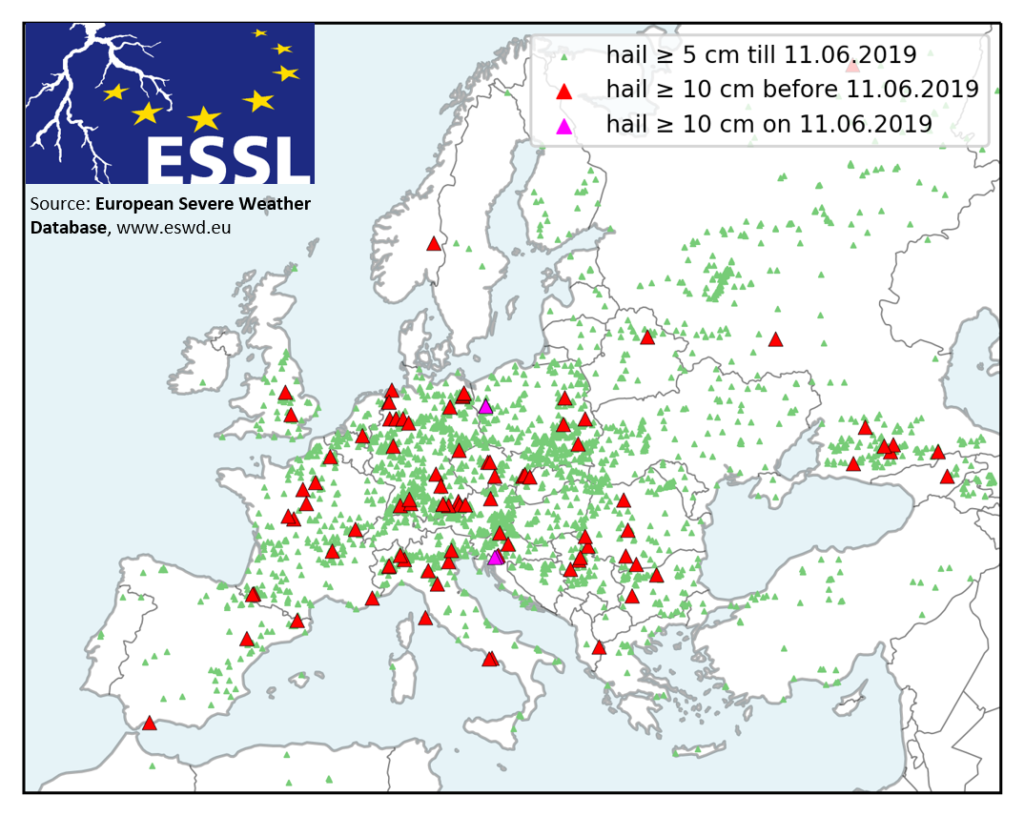
Severe hailstorms can cause extensive economic damage to both crops and properties. Report by Munich RE shows that damage of individual events can exceed billions of dollars as the risk has increased in the past decades. Hail damage to properties, such as cars, roofs and windows, becomes substantial when the diameter of hailstones approaches and exceeds 5 cm. Each year there are a number of such events when hail of this size occurs across Europe and this year, 2018, was no exception.

By looking at the ESWD dataset, we found 26 days, when hail exceeded 5 cm and caused significant damage to the properties. The spatial distributions of these major hail events and associated hail sizes can be found in in Fig. 1. The largest hail size was observed on 8 June 2018, when the town of Črnomelj, Slovenia was hit by giant hail up to 12 cm in diameter, destroying hundreds of roofs and cars. The hail swath on that day (40 km) was much shorter compared to long-lived hailstorms of 1 May in Poland (220 km) or the hailstorm of 30 June in southern Russia (200 km).

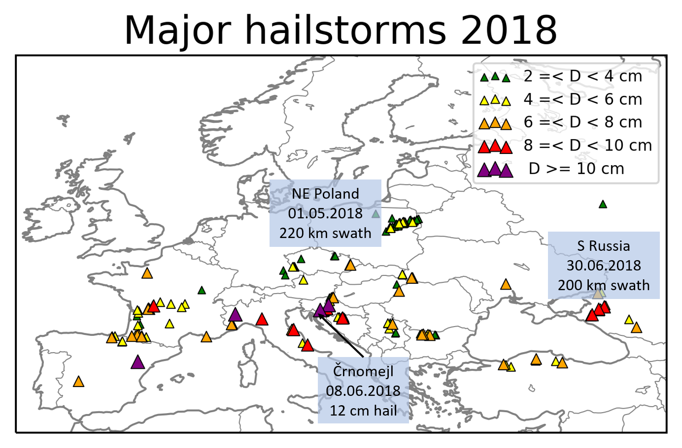
Fig. 1. Severe hail reports associated with 26 damaging hailstorm events over Europe in 2018. Size and colour of the symbol represent the observed hail size.

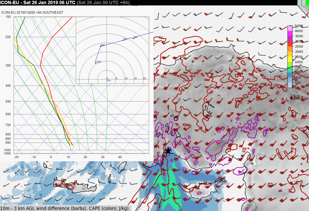
These damaging hailstorms occurred in an environment of moderate to high CAPE and bulk 0–6 km wind shear exceeding 15 m/s, conditions which favour strong updrafts and well-organized convection, including supercells. Our research shows that such conditions may become more frequent in the future. As we compare with the sounding database developed by Pucik et al (2015), most of these events occurred in typical conditions for damaging hailstorms (Fig. 2). Several of these events formed in rather weak vertical wind shear (i.e., bulk 0-6 km shear ranging from 10 to 15 m/s) but these cases were confined to the proximity of complex orography, where shear could be strongly enhanced locally.

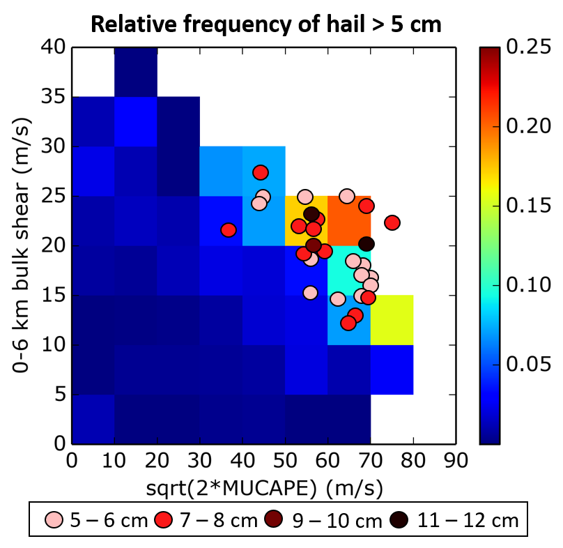
Fig. 2. Environments of damaging hailstorms over Europe in 2018 (dots) compared to the relative frequency of hail > 5 cm (colour bar) as a function of CAPE and 0-6 km bulk shear based on Pucik et al (2015). Colour of dots represents the maximum observed hail diameter with each event.

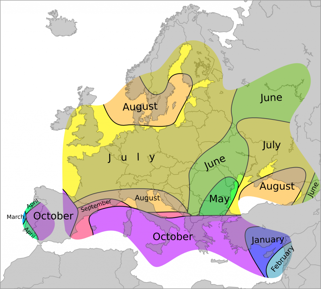
Description of individual events

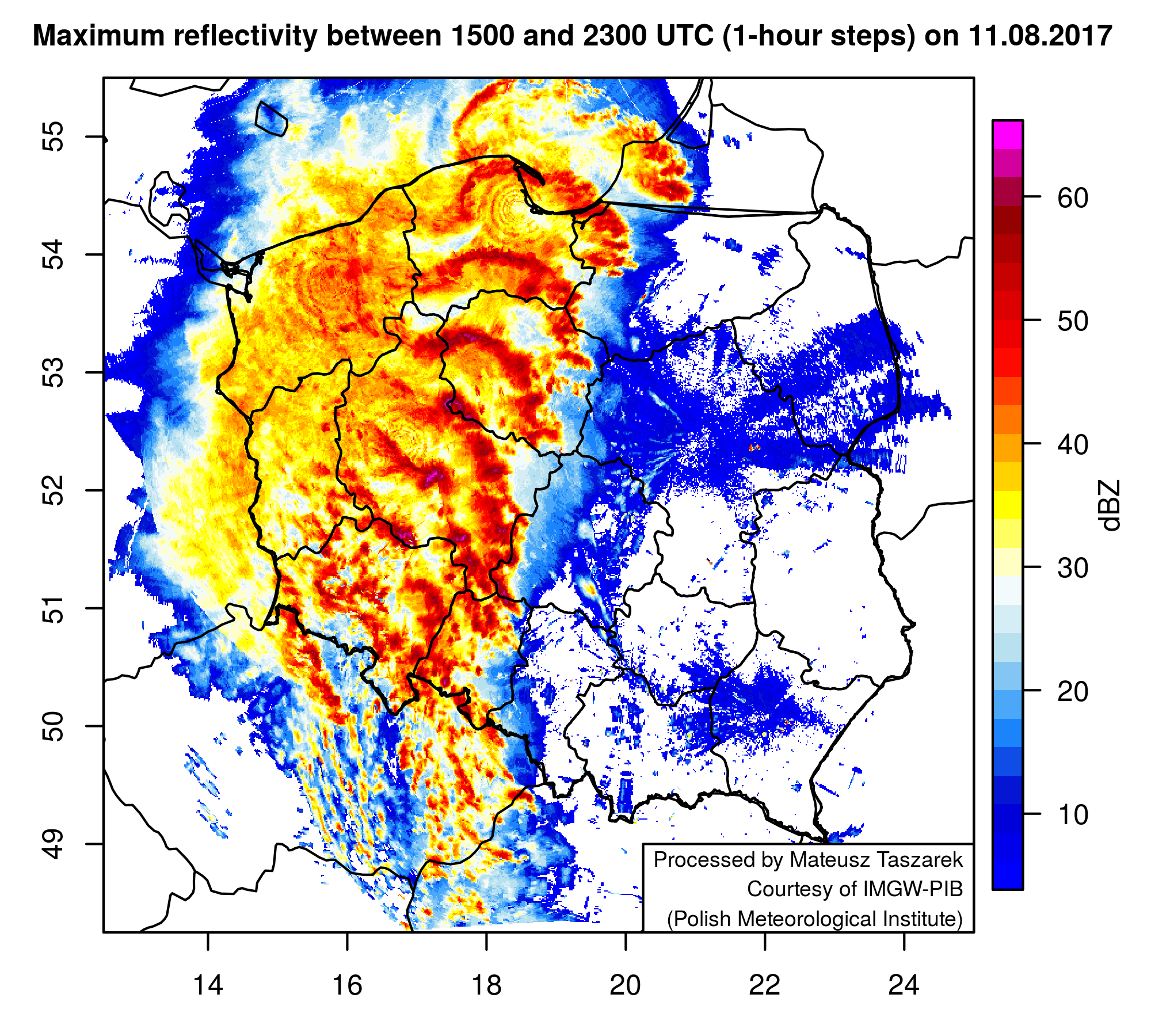
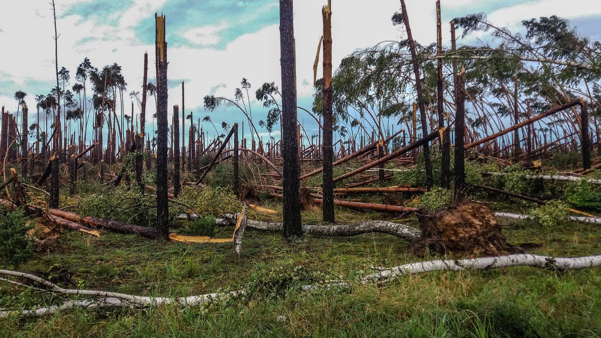
01.05.2018 (Poland). An isolated supercell cut a 220 km long hailswath across the regions of Mazowieckie and Podlaskie in northeastern Poland with hail up to 5 cm in diameter.

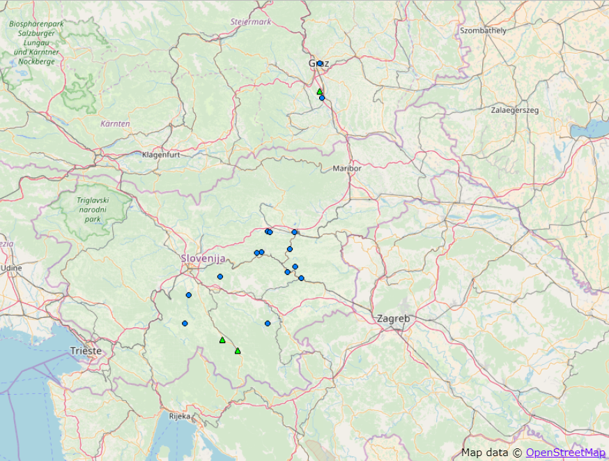
02.05.2018 (Slovenia). Very large hail was recorded in the districts of Lendava, Murska Sobota, Gornja Radgona and Ljutomer in northeastern Slovenia, with hailstones up to 6 cm in diameter. Hail damaged cars and roofs.

15.05.2018 (Bulgaria). Very large hail hit several villages and towns within a 120 km long path tracking through the districts of Vraza and Pleven in northwestern Bulgaria with hailstones up to 7 cm in diameter. Extensive damage to cars and trees was reported from the town of Pleven.

24.05.2018 (Spain). Hailstorm hit the town of Garciaz in Extremadura province, southwestern Spain, with hailstones up to 7 cm in diameter. Cars, roofs and fruit plantations were damaged by the storm.

26.05.2018 (France and Italy). Violent thunderstorms hit the regions of Aquitaine and Poitou-Charentes in southwestern France with a 100 km long hailswath originating near Bordeaux and devastating vineyards in the area. Hail up to 6 cm in diameter was reported. On the same day, very large hail, up to 7 cm in diameter was also reported from Piemonte province, northwestern Italy.  

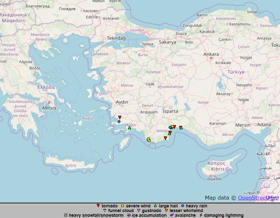
27.05.2018 (Turkey). Severe hailstorms hit Samsun province, northern Turkey. Six people were injured in Muratbeyli village as 6 cm large hailstones smashed car rear windows and roof tiles.

04.06.2018 (Italy). A right-moving supercell brought violent hailstorm to the town of Noceto in Emilia-Romagna province, northern Italy. Very large hail up to 8 cm in diameter damaged cars.

08.06.2018 (Slovenia and Croatia). Two very severe hailstorms occurred in Slovenia and Croatia. The town of Črnomelj in southern Slovenia was particularly hit as supercell produced hail up to 12 cm in diameter. Hundreds of cars, roofs and solar panels were seriously damaged. Another supercell hit the districts of Karlovačka, Zagrebačka and Krapinsko-Zagorska in central and northern Croatia. Hail up to 10 cm in diameter hit Grabovec town, damaging cars.

11.6.2018 (Germany and Czech Republic). Violent, wind-driven hailstorm from supercell damaged roofs, facades and windows in  Furth im Wald town in Bayern state, southeastern Germany, and along the Czech-German border. Hail up to 6 cm in diameter was observed.

12.6.2018 (Ukraine). Supercells produced very large hail over Uzhhorod town and Irshava district in Zakarpatska province, southwestern Ukraine. Car rear windows and roof tiles were smashed by hailstones up to 6cm in diameter. On the same day, a violent hailstorm hit villages in the northern parts of Bihor County in western Romania. Hodoš village was worst hit by hailstones up to 6cm in diameter, destroying roof tiles.

13.6.2018 (Serbia). Supercell produced wind-driven hail with diameter up to 6 cm over central and east Serbia. Extensive damage to crops, windows, roofs, cars and facades of houses was observed.

26.06.2018 (Turkey). Violent hailstorm with hail up to 6 cm in diameter caused damage in Düzce province, northwestern Turkey.

28.06.2018 (Ukraine). A violent hailstorm hit areas in Mykolayivska province, southern Ukraine. Hailstones up to 6 cm in diameter caused extensive damage in Yuzhnoukrainsk town.

30.6.2018 (Russia). An isolated, long-lived supercell produced more than 200 km long hail swath with hail up to 8 cm in diameter in the districts of Krasnoarmeyskiy, Timashevsk, Bryukhovetskaya and Pavlovskaya in Krasnodar Region, southern Russia. Novokorsunskaya town was worst hit by very large hail which caused extensive damage to crops, cars, car windshields, roofs and windows. Additionally, very large hail up to 6 cm in diameter also caused extensive damage to cars and houses in Pavlo-Ochakovo area, Rostov province.

01.07.2018 (Russia). A violent hailstorm hit Stavropol region, southern Russia. Hail up to 7 cm in diameter hit the local areas of Bekeshevskaya town.

04.07.2018 (France). Several hailstorms produced very large hail up to 8 cm in diameter over France. 11 people were injured in the Poitou-Charentes region village of Saint-Sornin, where 7 cm hail produced extensive damage to roofs. Houses in villages south of La Rochefoucauld town were badly damaged and rendered uninhabitable by water damage following the very large hail. In Aquitaine region, southwestern France, very large hail up to 6 cm in diameter caused significant damage in some places east of Pau city.

14.07.2018 (Italy). A severe hailstorm hit Piemonte province, northwestern Italy. The town of Chivasso was hit by giant hail up to 10 cm in diameter. Cars and roofs were damaged during the hailstorm.

16.07.2018 (Italy). Several instances of very large hail, up to 8 cm, were reported from Marche province, eastern Italy. Hail caused extensive damage to cars in the town of Pesaro and surrounding villages.

21.07.2018 (Bosnia and Herzegovina). Very large hail up to 8 cm reported from Srpska territory, northern Bosnia and Herzegovina. 1 person was injured by 6 cm large hail in Prijakovci village, north of the city of Banja Luka. Roofs and cars were damaged by the storms in several villages.

24.07.2018 (Turkey). A strong hailstorm hit parts of Kastamonu province in northern Turkey causing extensive damage to cars and houses in Kuzyaka and Seyh villages by hailstones of at least 5 cm in diameter.

05.08.2018 (Czech Republic). Very large hail up to 6 cm was reported from villages in Zlín and Olomouc regions, eastern Czech Republic. Cars and roofs damaged by the hail.

07.08.2018 (France). Very large hail up to 6 cm (weighing 150 g) was reported in Basse-Normandie region, northern France. Roofs, cars and vegetation were damaged.

09.08.2018 (France). Very large hail up to 7 cm fell over Marseille city and Aubagne town, southern France.

28.08.2018 (Spain). Very large hail up to 7 cm in diameter was observed in Euskadi region, northern Spain.

02.09.2018 (Italy). Very large hail up to 8 cm was reported from Abruzzo province, eastern Italy with extensive damage to cars and roofs.

05.09.2018 (Spain). A severe hailstorm hit Albalate del Arzobispo town in Aragón province, northeastern Spain with giant hail up to 11 cm in diameter causing damage to roofs and cars.

13.09.2018 (Turkey). Severe hailstorm with hail up to 6 cm in diameter hit Kastamonu city in northern Turkey. Extensive damage was inflicted to cars and houses.

Flash floods in Austria and Slovenia

The convective season is beginning over Europe and the severe thunderstorms of yesterday, 16th April, are a good example of that. We have received a number of severe weather reports from Slovenia and southeastern Austria, where flash floods and large hail up to 3 cm in diameter occurred in the late afternoon (Fig. 1). The event that received the most attention was a flash flood in Graz, with rainfall totals of up 80 mm. A number of streets, as well as cellars, parking lots and even the shopping mall, were flooded.

Fig. 1 Severe weather reports collected for 14 April 2018 across Slovenia and southeastern Austria. Blue circles denote heavy rainfall reports and green triangles large hail reports.

Anticipating situations conducive to flash flooding may be quite tricky, as it often takes a quasi-stationary, long-lived thunderstorm to deliver several waves of heavy rainfall over an area. Yesterday was no exception. Thunderstorms formed in an environment featuring moist, southeasterly flow at the surface, CAPE values on the order of several hundred J/kg and an increasing southerly flow aloft (Fig. 2). A very moist profile in low to mid troposphere along with low cloud bases was evident, both from the forecast sounding over southeastern Austria and from the observed sounding in Zagreb, Croatia (Fig. 3). These conditions suggested a potential for very heavy rainfall with thunderstorms as little precipitation would evaporate when falling from the cloud.

Fig. 2 A 15 UTC forecast ICON-EU forecast of 10 m wind (arrows) and 2 m dew-point (colours), initialized at 00 UTC. Forecast sounding was taken at the location marked by red star.

Fig. 3 12 UTC sounding taken at Zagreb. Courtesy of University of Wyoming.

Even so, the increasingly southerly flow aloft meant that thunderstorms could hardly stay confined to one location and would move northward with time. Yet, that has not happened, as one can see from this radar animation shared by ZAMG, which reveals a number of instances of storms stagnating over one particular location. This is because storms were propagating (propagation represents the movement of the thunderstorm caused by the formation of new cells) along the convergence zone towards the moister and more unstable airmass in the south. With a mid- to upper-tropospheric flow almost parallel to the convergence zone and the propagation cancelling out the advection of individual cells to the north by mean wind, some of the thunderstorm clusters became quasi-stationary and produced excessive rainfall.

Fig. 4 16:00 UTC satellite (combination of visible and infrared channels) and radar (OPERA composite) imagery. 2m temperature (red numbers), 2 m dewpoint (green numbers) and 10 m wind (barbs) are plotted for individual stations. Thick black line denotes the approximate location of convergence zone. OPERA radar data © EUMETNET, satellite data © EUMETSAT.

This case shows how demanding it can be to correctly anticipate flash flood situations with thunderstorms when numerical models underestimate the rainfall sums, which is often the case with convective phenomena.

Convective windstorms in 2017 Episode 3: 11 August

The third most socially impactful convective windstorm case in 2017 occurred on 11 August, in a belt from the northern Czech Republic to northern Poland with 6 fatalities and many injuries.

Situation began with a quasi-linear convective system over Austria and the Czech Republic, which formed around 10 UTC, paralleling strong prevailing flow in low to mid troposphere. However, at this point, only marginally large hail and heavy rain occurred as the system remained elevated. System progressed northward towards the borders of the Czech Republic and Poland, encountering progressively warmer airmass near the surface. As soon as the system became surface based around 15 UTC, it began producing severe wind gusts (Fig. 1). Widespread forest blow downs were noticed already on the Czech side of the border. As the system moved towards north-northeast, it encountered increasingly favourable conditions for severe convection, strengthened and eventually transformed into a large bow-echo at 18 UTC. Just before this transition, an embedded supercell formed within the system, as evidenced by high reflectivities near the apex of the system (Fig. 2). Besides severe wind gusts, large hail up to 5.5 cm was observed at this point. Transition into the bow-echo was accompanied by a rapid increase in the severe wind damage reports. As the system moved offshore to the Baltic Sea after 22 UTC, it produced a 42 m/s wind gust at Milejewo near the coastline. A continuous swath of wind damage was noted from the northern Czech Republic all the way towards the Baltic Sea coastline in a 7 hour long rampage. A spectacular shelf cloud accompanied the passage of the bow-echo (Fig. 3)

Fig. 1 Chronological progression of severe wind reports in a convective windstorm of 11 August 2017 across northern Czech Republic and Poland.

Fig. 2 Composite image of maximum reflectivity in vertical column at the hourly time steps between 15 and 23 UTC. Courtesy of Mateusz Taszarek and IMGW.

Fig. 3 Shelf cloud observed on the leading edge of the bow-echo near the town of Krotoszyn at 18:15 UTC. Photo by Mateusz Taszarek

At the height of the storm, 180 000 customers were out of power and many roads were blocked by fallen trees. Damage to the forestry was widespread (Fig. 4) with 39 200 ha of forests completely destroyed and 40 500 ha partially damaged. The volume of fallen wood reached almost 10 millions of m³. Together with 20 000 damaged buildings and financial costs of the storm estimated in the range of 500 millions to 1 billion €, this was likely the most impactful convective storm to hit Poland in decades.

Fig. 4 Aftermath of the 11 August 2017 convective windstorm in Poland. Photo by Grzegorz Zawiślak.

This convective storm was also record breaking for the ESWD. Altogether, more than 1200 severe weather reports were collected, which constitutes most reports ever submitted per event in the history of the database.

Environment capable of such extreme convective windstorm featured a deep cyclone at 500 hPa centered over the Alpine range with a belt of 20 + m/s southerly flow stretching from Croatia towards western Poland (Fig. 5). A short-wave trough was translating from Austria northwards. At the same time, a wavy frontal boundary extended from northwestern Austria through the Czech Republic into eastern Germany and western Poland (Fig. 6). In this setup, a warm and humid airmass has advected over Poland, with 2 m dew points exceeding 20 °C. Combination of high values of CAPE and a strong lower tropospheric shear, exceeding 20 m/s in the 0-3 km layer, created very favourable conditions for development of a bow echo (Fig. 7). Lift provided by cold pool from the already ongoing convective system and a well defined convergence zone located across western Poland resulted in widespread initiation of new convective cells, which quickly merged into a large convective system.

Fig. 5 ECMWF forecast of 500 hPa geopotential height (black contours), temperature (colors) and wind (barbs) for 11 August 12 UTC, initialized at 00 UTC.

Fig. 6 ECMWF forecast of 850 hPa geopotential height (black contours), temperature (colors) and wind (barbs) for 11 August 12 UTC, initialized at 00 UTC.

Fig. 7 COSMO-DE forecast of CAPE (colors, J/kg) and 0-3 km bulk vertical wind shear (barbs and contours, m/s) for 11 August 15 UTC, initialized at 00 UTC. Forecast sounding and hodograph correspond to the location marked by a blue star.

ESSL would like to thank Skywarn Polska and Amateur Meteorological Society of the Czech Republic for many submitted reports documenting the windstorm case. Furthermore, thank you goes to Artur Surowiecki for information on the impacts of the storm, Mateusz Taszarek and IMGW for the radar data, and Grzegorz Zawiślak for the photo of windstorm damage.

Additional information regarding the windstorm impacts in the Czech Republic can be found here (in Czech) and regarding the forest damage in Poland here (in Polish).


Convective windstorms in 2017 Episode 2: 17 September

The event with the second highest societal impact after the Moscow windstorm, occurred on 17 September in a swath from Bosnia and Herzegovina to Ukraine. It was also the last severe convective windstorm case of 2017. The date is actually well after the climatological peak of severe storm activity in the area, which is in June and July.

The event started with a cluster of thunderstorms impacting Split, Croatia, in the morning hours. This activity produced very large hail up to 5 cm in diameter that resulted in damage to cars. The first severe wind gusts were reported from Bosnia and Herzegovina and the convective system reached its peak intensity as it raced across northern Serbia and southern Ukraine between 11 and 16 UTC (Fig. 1), with measured wind gusts reaching up to 35 m/s. Widespread damage was reported, roofs were torn off of buildings, powerlines snapped and trees uprooted. The last severe wind gust reports were received from around 17 UTC over Ukraine. Overall, the system killed 10 and injured 94 along its track. Some of the damage suggests that much stronger wind speeds, than the measured maximum of 35 m/s, must have been involved.

Fig. 1 Chronological progression of severe wind reports in a convective windstorm of 17 September 2017 across southeastern Europe.

Radar observations of the storm show that the system, while not very large, involved very high radar reflectivities of over 60 dBz (Fig. 2). Over northwestern Romania, it attained a classic “bow-echo” shape, which is typically associated with damaging wind gusts (Fig. 3). The system moved extremely fast between Serbia and Romania, covering a distance of 400 km in a mere 3 hours.

Fig. 2 12:00 UTC satellite (combination of visible and infrared channels and radar (OPERA composite) imagery. OPERA radar data © EUMETNET, satellite data © EUMETSAT.

Fig. 3 15:00 UTC satellite (combination of visible and infrared channels) and radar (OPERA composite) imagery. OPERA radar data © EUMETNET, satellite data © EUMETSAT.

The fast movement speed could be attributed to the combination of strong background flow in the atmosphere and a strong cold pool of the system, as the temperature dropped by over 10°C at some locations in the path of the storm. The convective system formed ahead of the deep trough with strong southwesterly flow exceeding 30 m/s and 20 m/s at 500 and 700 hPa respectively. (Fig. 4) Combined with southerly to southeasterly flow at the surface of around 5 m/s, very strong vertical wind shear was present, conducive to well-organised convection. The 12 UTC sounding taken from Beograd just south of the storm system reveals very dry air in the lower troposphere and confirms the presence of pronounced vertical wind shear. In this perspective, the situation actually resembles the Moscow case of 29 May 2017. While the original sounding does not show any CAPE, its modification with observed dewpoints above 10°C ahead of the storm shows that enough CAPE was present for development of deep convective updrafts with high cloud bases (Fig. 5).

Fig. 4 17 September 2017 12 UTC (Left) 500 hPa geopotential height (black contours), temperature (colour scale) and wind barbs, (Right) The same as left, but for 700 hPa. Data based on ERA-Interim reanalysis.

Fig. 5 Modified Beograd 12 UTC sounding. Green line represents modified dew point curve, orange line represents the Lifted Condensation Level (LCL) and red hatching CAPE for modified surface parcel. Courtesy of University of Wyoming.

The presence of rather dry conditions at the surface led to the development of a dust storm along the gust front of the storm. Besides the spectacular appearance (Fig. 6), however, dust storm created very dangerous driving conditions with practically zero visibility, as evidenced by numerous videos submitted by surprised drivers.

Fig. 6 Photographs depicting dust lofted ahead of the progressing storm near Inđija, Serbia. Courtesy of Dejan Primorac.

ESSL would like to thank Severe Weather Serbia for the wealth of information they provided about this event, as well as Dejan Primorac for his agreement to share the photos of the dust storm.


Convective windstorms in 2017 Episode 1: 29 May

As promised, we would like to bring you an overview of the major convective windstorms in Europe last year.

The first event we are going to cover is the case of 29 May 2017 in Russia. This event did not feature one of the longest-lived convective windstorms of that year in Europe, nor did it involve the highest measured wind gusts (which reached up to 30 m/s). Yet, its societal impact was the largest of all the cases. As the windstorm hit the metropolitan area of Moscow, it resulted in 18 fatalities and 168 injuries (economic loss estimated at 25 million rubles). The first reports of wind damage came in from 11:15 UTC. Between 12 and 13 UTC, the convective system reached its maturity as it passed over Moscow and it decayed shortly after 14 UTC (Fig. 1).

Fig 1. Chronological progression of severe wind reports in a convective windstorm of 29 May 2017 in the Moscow area.

Radar imagery shows that at 12:30, a linearly oriented convective system was moving into the Moscow area. The convective system was not particularly large, without very high reflectivity values and did not show a classic “bow-echo” structure, which would typically be associated with damaging wind gusts (Fig. 2). The apparent lack of strong updrafts was also confirmed by virtually no lightning activity in the southern part of the system (Fig. 3).

Fig 2. Precipitation intensity (mm/h) s in Moscow region for 12:30 UTC 29.05.2017 (data from Web-GIS ‘Meteorad’ of the Central aerological observatory based on Roshydromet radar network). Arrow points to the direction of the storm movement.

Fig. 3 Combined information on weather phenomena (based on Roshydromet radar network) and lighting detection networks (WWLN, ALVES, Vaisala LS-8000) in Moscow region for 12:30 UTC 29.05.2017 (data from Web-GIS ‘Meteorad’ of the Central aerological observatory). Arrow points to the direction of the storm movement.

The reason for this untypical behaviour were the background environmental conditions. The convective storm formed ahead of an advancing mid-tropospheric trough (Fig. 4 left). Buoyancy was rather low with CAPE values around 400 J/kg according to the Era-Interim. At the same time, vertical wind shear was moderate, with 0-6 km bulk shear values around 15 m/s (Fig. 4 right). Overall, the environment did not seem to be too favourable for an extremely severe convective event, which would be typically anticipated in high CAPE and high shear regime. However, a combination of very strong flow in the lower troposphere and a dry boundary layer (Fig. 5) created favourable conditions for powerful downdrafts transporting high momentum air down from above.

Fig. 4 (Left) 500 hPa geopotential height (black contours), temperature (colour scale) and wind barbs, (Right) CAPE (colour scale) and 0 – 6 km bulk vertical wind shear (wind barbs) for 29 May 2017 12 UTC according to ERA-Interim reanalysis. Blue dot represents location of Moscow.

Fig. 5 Moscow Dolgoprudnyj 12 UTC sounding. Courtesy of University of Wyoming.

The convective system weakened soon after leaving the Moscow area, probably suffering from the lack of ideal environmental conditions. Nevertheless, this case  illustrates that high-impact convective windstorms are possible in a wide variety of conditions.

ESSL would like to thank Alexander Chernolusky from the A. M. Obukhov Institute of Atmospheric Physics for his contribution to this case study.